Colorado State University

Research

Our primary research interests are in tropical weather and climate with expertise in field experiments, remote sensing, and numerical modeling. A central focus of our research is studying the structure and intensification of tropical cyclones throughout their life-cycle from genesis to extratropical transition. This research is accomplished through the collection and analysis of research quality observations in conjunction with high-resolution numerical weather prediction. A significant component of our research effort is also aimed at improving meteorological analysis techniques, open source software tools, and weather and climate forecasting from daily to seasonal timescales.


Figure

Dynamics, Thermodynamics, and Microphysics of Extreme Rainfall observed during PRECIP

NSF Prediction of Rainfall Extremes Campaign In the Pacific (PRECIP)

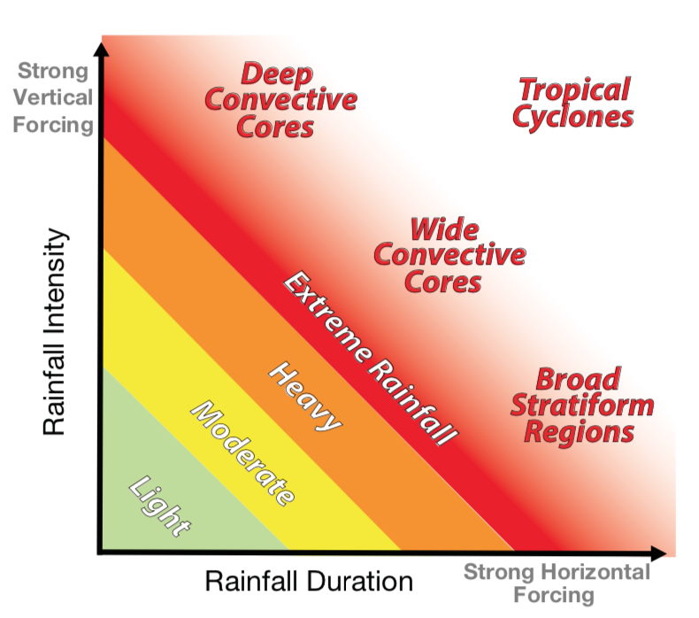
Extreme rainfall is a high impact weather phenomenon that profoundly affects people around the world, but our fundamental understanding and quantitative forecast skill for these events remains limited. To address these important scientific and forecast challenges, PRECIP in summer 2021 over Taiwan will be conducted to improve our understanding of the multi-scale dynamic, thermodynamic, and microphysical processes that produce extreme precipitation.

Acknowledgement: NSF AGS-1854559

Figure

Heating, Cooling, and Rapid Intensity Change in Tropical Cyclones

ONR Tropical Cyclone Rapid Intensification (TCRI)

The central objectives of this research are to improve our understanding of diabatic heating and cooling during TC rapid intensification (RI). The proposed research will accomplish these objectives through an analysis of field observations in conjunction with high-resolution numerical modeling. The central hypothesis of this research is that RI is caused by high efficiency diabatic heating and associated potential vorticity generation that requires cooperation across multiple spatial and temporal scales.

Acknowledgement: ONR N000142012069

Figure

Improvement of sub-seasonal to seasonal Atlantic basin hurricane forecasts

Tropical Cyclone Forecasting

CSU has been issuing seasonal Atlantic hurricane forecasts since 1984. These forecasts have evolved since their inception and now include sub-seasonal (e.g., two-week) forecasts issued during the peak months of the hurricane season. While these forecasts have shown skill when issued in real time, there remains significant room for improvement. Current research involves a better understanding of the drivers of sub-seasonal to seasonal variability driving hurricane activity, with a focus on vertical wind shear.

Acknowledgement: G. Unger Vetlesen Foundation and our project sponsors -- Liberty Mutual Insurance, Insurance Information Institute, Weatherboy and Evex

Figure

Development of Remote Sensing Research Tools and Technology

NSF Lidar Radar Open Software Environment (LROSE)

Remote sensing observation tools such as radar, lidar, and satellite provide important data to better understand and forecast various aspects of high impact weather. This project will assist in developing new technology and tools to address community needs.

Acknowledgement: NSF AGS-2103776

Figure

NSF CSU Sea-Going Polarimetric (SEA-POL) Radar

NSF CSU SEA-POL radar

SEA-POL is a NSF Community Facility available for community requests for deployment in the U.S. and around the globe. Numerous science opportunities are possible with a portable, 5-cm wavelength radar in atmospheric science including advances in tropical and mid-latitude weather, regional climate and climate change, cloud microphysics, dynamics of convective storms, and extreme weather impacts. SEA-POL can also contribute to interdisciplinary science in oceanography, hydrology, and water resources.

Acknowledgement: NSF AGS-2113042

Figure

Tropical Cyclone Analysis Project

NOAA Tropical Cyclone Analysis Project

This is a NOAA funded research to operations project using aircraft reconnaissance observations to improve forecaster support products for analysis of tropical cyclone intensity and structure.

Acknowledgement: NOAA NA22OAR4590521