Colorado State University

Tropical Cyclone Forecasting

Improvement of sub-seasonal to seasonal Atlantic basin hurricane forecasts

CSU has been issuing seasonal Atlantic hurricane forecasts since 1984. These forecasts have evolved since their inception and now include sub-seasonal (e.g., two-week) forecasts issued during the peak months of the hurricane season. While these forecasts have shown skill when issued in real time, there remains significant room for improvement. Current research involves a better understanding of the drivers of sub-seasonal to seasonal variability driving hurricane activity, with a focus on vertical wind shear. More details about current and past TC forecasts can be found HERE.

Acknowledgement: G. Unger Vetlesen Foundation and our project sponsors -- Liberty Mutual Insurance, Insurance Information Institute, Weatherboy and Evex


Why was the 2018 Atlantic hurricane season more active than anticipated and how we can better characterize uncertainty in seasonal hurricane forecasts?

Figure

Group Members: Philip J. Klotzbach , Michael M. Bell

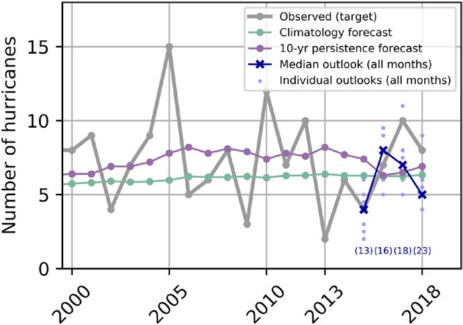
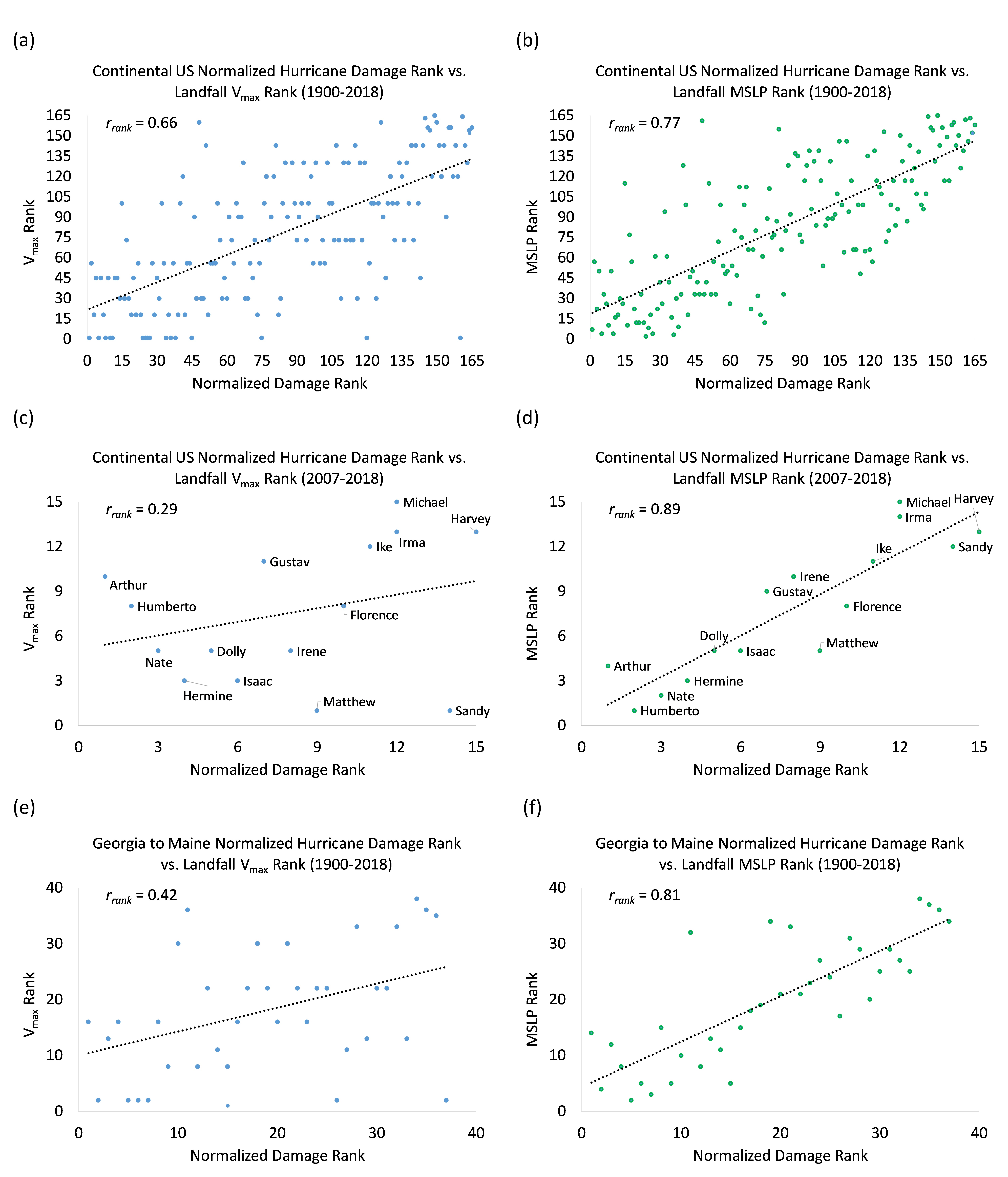
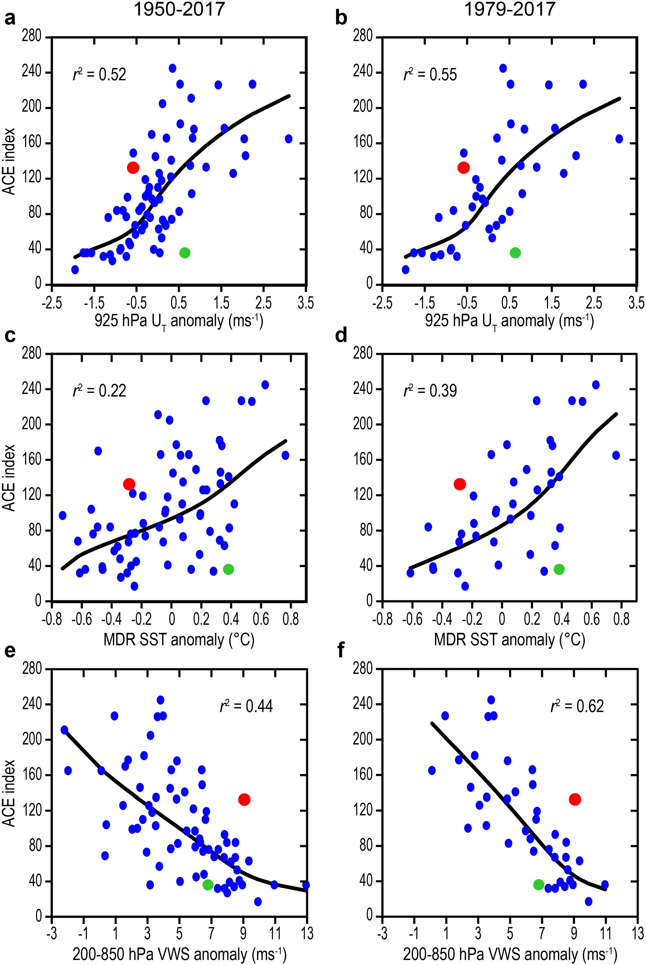
Our group at CSU collaborated with Tropical Storm Risk, based at the University College-London, to investigate the 2018 Atlantic hurricane season in detail. We noted that the season was more active than was anticipated by seasonal forecasts issued prior to the peak of the season (e.g., before mid-August). The season was also more active than would be anticipated given long-term historical relationships between large-scale conditions known to impact Atlantic hurricanes during the peak of the season (August-September) and Atlantic hurricanes. The season ended up above-average for most TC parameters, despite above-normal tropical Atlantic vertical wind shear, below-normal tropical Atlantic SSTs and borderline weak El NiƱo conditions - all of which generally lead to below-average Atlantic hurricane activity. Much of the activity in 2018 occurred at higher latitudes, where Atlantic seasonal TC forecasts generally have little (if any) predictability. Our study argues that probabilistic methods be used to issue Atlantic seasonal forecasts in future years, in order to better account for these types of outlier seasons.


How has the relationship between the Madden-Julian oscillation and Quasi-Biennial oscillation changed going back in time?

Figure

Group Members: Philip J. Klotzbach , Michael M. Bell

Klotzbach et al. (2019) examined the relationship between the quasi-biennial oscillation (QBO) and the Madden-Julian oscillation (MJO) using long-term reconstructed indices. There have been several studies noting a strong relationship between boreal winter QBO phase and MJO amplitude since the late 1970s, with an east phase of the QBO associated with higher MJO amplitude. This study finds that the relationship has only become strong since the late 1970s, with no significant relationship between QBO phase and MJO amplitude prior to that time. While there is increased uncertainty going back in time with both QBO and MJO indices, there is relatively high confidence in these indices at least since the late 1950s. This study argues that changes in static stability associated with a cooling lower stratosphere and warming upper troposphere (likely caused by climate change) may have sensitized the region near the tropopause to QBO-induced changes in stability profiles.


How do maximum sustained wind and minimum sea level pressure relate to normalized damage?

Figure

Group Members: Philip J. Klotzbach , Michael M. Bell

Atlantic hurricanes have historically been categorized using the Saffir-Simpson Hurricane Wind Scale, which ranks hurricanes based on their maximum sustained wind (e.g., Vmax). In this study, we investigate whether Vmax or minimum sea level pressure (MSLP) historically has worked as a better predictor of continental US hurricane landfall damage. We use the normalized hurricane damage dataset from Weinkle et al. (2018) and show that MSLP (r = 0.77) has a more significant correlation with damage than has Vmax (r = 0.66) for 165 continental US landfalling hurricane events since 1900 (Figure 7). The relationship has been much stronger for MSLP in recent years, where recent hurricanes like Ike (2008) and Sandy (2012) have done much more damage than would have been expected from their Saffir-Simpson Hurricane Wind Scale ranking. MSLP has also been a much better predictor of damage for hurricanes making landfall from Georgia to Maine, where hurricanes tend to be larger and more sprawling.