Colorado State University

NSF CAREER

Impacts of convective and stratiform processes on tropical cyclone intensity change

This study is investigating convective and stratiform processes in TC intensification through analysis of mesoscale observations, with a focus on aircraft and Doppler radar data. Recent studies have suggested that the radial location of deep convective bursts and stratiform precipitation relative to the RMW may play an important role in intensification efficiency. Testing new hypotheses using observations is needed to diagnose the physical processes responsible for TC intensity change and forecasts.

Acknowledgement: NSF AGS-1701225


Are the asymmetric dynamics of Hurricane Michael (2018) polygonal eyewall consistent with vortex Rossby wave (VRW) theory?

Figure

Group Members: Ting-Yu Cha , Michael M. Bell , Alex DesRosiers

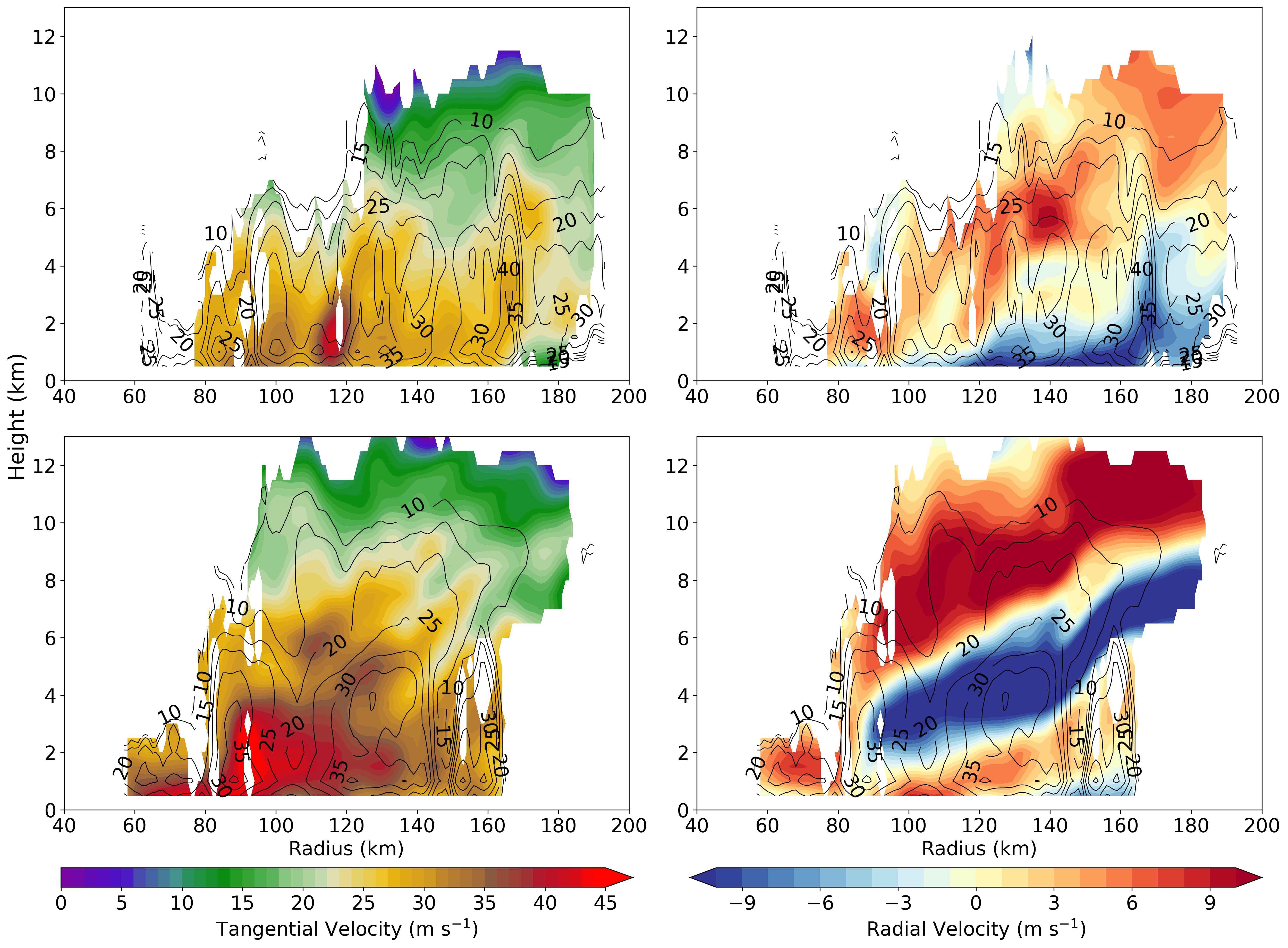
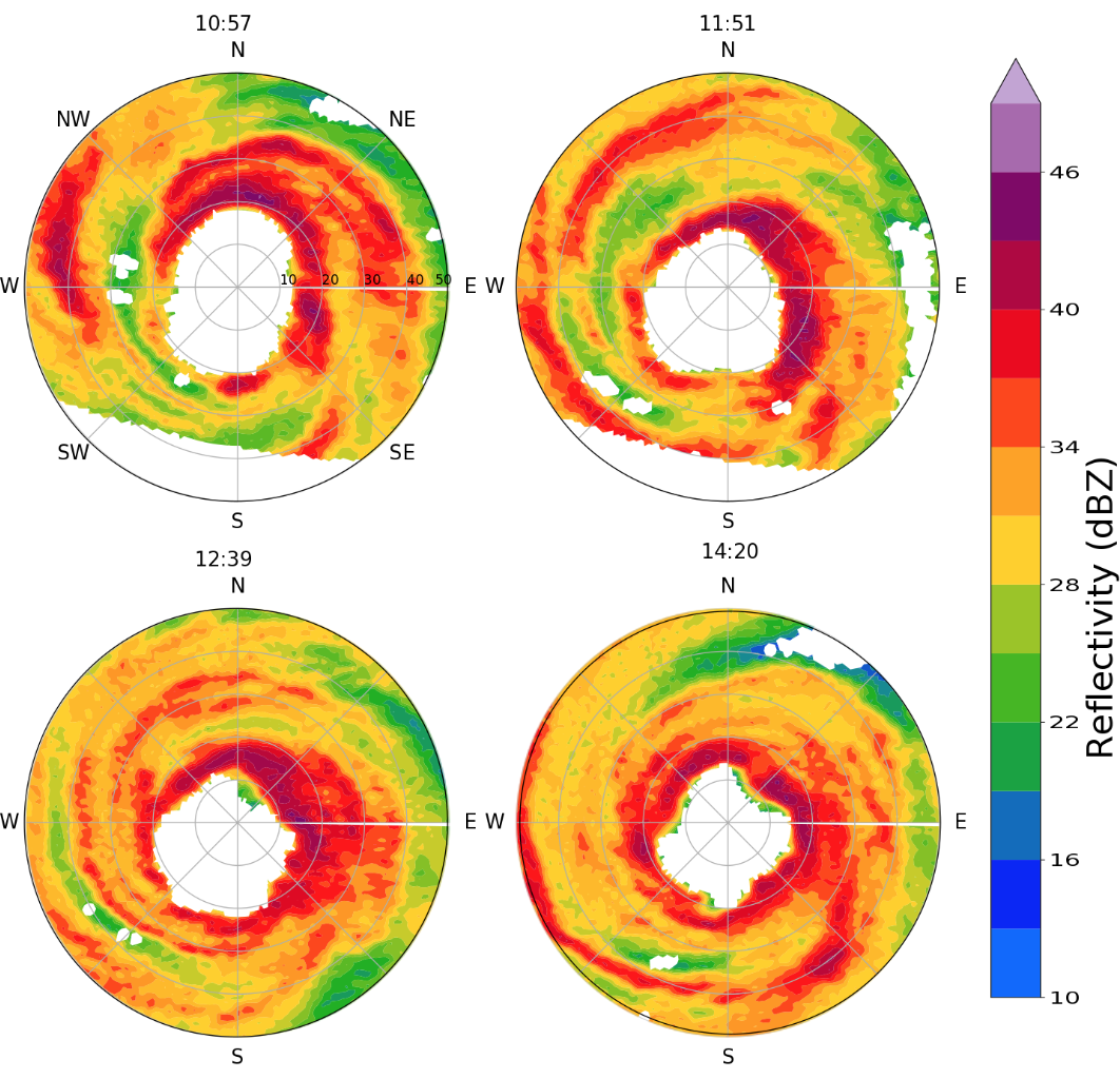
While polygonal eyewall shapes have been seen in previous hurricanes, the corresponding evolution of wind asymmetries has never been quantitatively deduced due to limitations from previous observations. Here we show the first observational evidence of the evolving wind field of a polygonal eyewall during RI to Category 5 intensity by deducing the winds at 5-minute intervals from single-Doppler Next Generation Weather Radar (NEXRAD) observations. The single Doppler radar analysis shows that the propagation speeds of different VRWs are consistent with linear wave theory.


How the wave pouch and vertical wind shear interactions play important roles in cyclongenesis in multi-scales?

Figure

Group Members: C. Chelsea Nam , Michael Bell

Tropical cyclogenesis of pre-depression Hagupit was delayed while it interacted with upper-level trough, experiencing strong VWS. For the downscale cascade from the synoptic to meso-alpha scale, our analysis showed that pre-depression Hagupit was significantly affected by the strong northwesterly vertical wind shear. However, Hagupit survived through the hostile, strongly sheared environment, and eventually developed into a tropical cyclone after it escaped from the influence of upper-level trough. The upscale cascade from the persistent deep convection and its vorticity amplification through vortex tube stretching was a key process that enabled the pouch to persist even under 20 m/s VWS. We highlight the roles of localized low-level shear and cumulus congestus clouds inside the wave pouch as the localized vertical vorticity generated from the convective cells is aggregated through a vortex merger process inside the marsupial pouch.


The Unconventional Eyewall Replacement Cycle of Hurricane Ophelia (2005)

Figure

Group Members: Naufal Razin , Michael M. Bell

Using flight-level and airborne radar data, Hurricane Ophelia was shown to have undergone an unconventional eyewall replacement cycle (ERC). Ophelia\'s ERC was unconventional because it occurred while the storm was at Category \1 intensity and located over anomalously cold sea surface temperatures. Airborne radar analyses showed that the expansion of Ophelia\'s wind field associated with the ERC occurred in the dominantly stratiform rainbands, indicating that the stratiform kinematics in Ophelia's rainbands played a dominant role in Ophelia's ERC.


How do the asymmetric processes impact Hurricane Matthew's (2016) Eyewall replacement cycle?

Figure

Group Members: Ting-Yu Cha , Michael M. Bell , Alex DesRosiers

Hurricane Matthew was observed by the NEXRAD KAMX, KMLB, and KJAX polarimetric radars and NOAA P-3 airborne radar when it approached the southeastern United States during an ERC event. The radar observations indicate that Matthew's primary eyewall was replaced with a weaker outer eyewall, but unlike a classic ERC, Matthew did not reintensify after the inner eyewall disappeared. The single-Doppler analyses indicate that the inner eyewall decayed a few hours after the P-3 flight, while the outer eyewall contracted but did not reintensify and the asymmetries increased episodically. The analysis suggests that the resilient outer eyewall was influenced by both environmental vertical wind shear and an internal vortex Rossby wave damping mechanism during the ERC evolution.


What separates developing and nondeveloping disturbances?

Figure

Group Members: C. Chelsea Nam , Dandan Tao , Michael M. Bell

To be, or not to be, that is the question of tropical cyclogenesis. Only about 15-20 % of African Easterly Waves develop into tropical cyclones (TCs). A WRF ensemble was created with multiple TC simulations spanning the relevant parameter space for three variables; 1) the VWS magnitude, 2) the environmental humidity, and 3) the initial vortex intensity. Unmeasurable random perturbations result in widely diverging scenarios in TC genesis in moderately sheared and dry environments. Here we hypothesize that the combination of moderate shear and dry air makes an unstable condition for a vortex to intensify or decay, which implifies that TC genesis in such environments may be intrinsically unpredictable in deterministic sense. We are currently looking at the link between the deep convection and the realignment of mid-level and low-level vortices comparing the developing and non-developing ensemble members.


On the contributions of incipient vortex circulation and environmental moisture to tropical cyclone expansion

Figure

Group Members: Jonathan Martinez , C. Chelsea Nam , Michael M. Bell

Idealized numerical simulations of tropical cyclones are created to investigate the relative contributions of incipient vortex circulation and environmental moisture to tropical cyclone expansion. The principal findings demonstrate that an initially large vortex can expand more quickly than its relatively smaller counterpart. Increasing the environmental moisture further promotes expansion but mostly expedites the intensification process. Differences in the amount and scale of outer-core convection are associated with varying the incipient vortex circulation, resulting in variable expansion rates. Note: This project was also funded by the National Science Foundation Bridge to the Doctorate Fellowship Award 004863-00003.